











Roads don’t create wealth. Movement does.
A plot sitting eight kilometres from the city centre can be worth far less than a plot fourteen kilometres away — simply because one takes forty-five minutes to reach and the other takes fifteen. Distance is a number on a map. Connectivity is what that number actually feels like in daily life.
For decades, buyers in Nagpur and across India have judged land the same way: “How many kilometres from the city?” It’s an easy question to ask, but it often leads to the wrong answer. Two plots can sit at an identical distance from Nagpur’s Zero Mile and still have completely different futures — one surrounded by highways, schools, and growing employment centres, and the other cut off by poor roads and no public transport.
This guide breaks down why travel time, road quality, and infrastructure planning matter more than raw distance — and how you, as a buyer, can evaluate connectivity before you commit your savings to a plot. This is educational content meant to help you ask better questions, not a promise of returns. Nobody, including us, can guarantee future appreciation. What we can do is explain the factors that experienced buyers and planners consistently look at.
Table of Contents
Why Distance Alone Doesn’t Determine Property Value
Distance is measured in a straight line or along a single route. It doesn’t account for road width, traffic signals, potholes, encroachments, or whether a route even exists in the first place. Two plots that are both “10 km from the city” can have completely different realities on the ground.
Consider two hypothetical layouts near Nagpur:
- Plot A sits 10 km away but is connected by a narrow, single-lane road that floods during monsoon and has no direct bus route.
- Plot B sits 14 km away but is connected via a state highway with streetlights, drainage, and a proposed metro extension nearby.
On paper, Plot A looks closer and therefore “better.” In practice, Plot B is easier to live in, easier to sell later, and easier to reach on a normal working day. This is why serious buyers and planners look past the kilometre count and ask a more useful question: how long does it actually take to get there, and how will that change over the next five to ten years?
Distance is static. Connectivity is dynamic — it improves (or worsens) as roads are built, widened, or neglected. That dynamism is exactly what drives long-term demand.
How Connectivity Creates Demand
Good connectivity doesn’t just make a commute easier. It changes the way an entire area functions over time.
Daily commuting. When travel time from a locality to workplaces, schools, and markets shortens, more families are willing to consider it as a place to live. A 30-minute commute is a normal trade-off for many buyers; a 90-minute commute is often a dealbreaker, regardless of how cheap the land is.
Residential demand. As commute times fall, more people actively search for homes and plots in that area. This is one of the most consistent patterns in urban growth — residential demand tends to follow accessible roads, not just cheap land.
Commercial activity. Shops, clinics, small offices, and service businesses set up where footfall and vehicle movement already exist. Better roads bring more people through an area, and commercial activity naturally follows.
Business growth. Once commercial activity picks up, larger businesses — showrooms, warehouses, franchises — start considering the location too, which further strengthens local infrastructure and employment.
Lifestyle convenience. Proximity to a well-connected road often means faster access to hospitals in an emergency, easier school runs, and simpler weekend trips. This convenience is a genuine quality-of-life factor that buyers increasingly prioritise, especially families and working professionals.
Put simply: connectivity is not just about reaching a place faster. It’s about how many other people find it easier to reach that place too — and that collective movement is what builds a locality over time.
Infrastructure That Can Influence Property Value
No single factor decides an area’s future, but a combination of these typically plays a meaningful role in how a location develops.
Highways and expressways. Arterial routes like national highways and expressways (for example, corridors such as the Samruddhi Mahamarg near Nagpur) reduce travel time between a locality and major economic centres. Areas near well-planned highway access tend to see faster infrastructure follow-through, such as better internal roads and utility connections.
Ring roads. Outer or inner ring roads redistribute traffic away from congested city centres, making peripheral areas more accessible without forcing residents through the busiest parts of the city. Localities near ring road junctions often benefit from this improved circulation.
Metro projects. Even proposed or under-construction metro lines can influence how buyers perceive an area, since public transport reduces dependency on private vehicles and lowers the effective “cost” of distance.
Flyovers and junction improvements. Small-scale infrastructure like flyovers and signal-free junctions can meaningfully cut travel time on routes that were previously bottlenecked, even without any change in the map distance.
Employment hubs. Proximity to established or upcoming employment zones — IT parks, industrial hubs, logistics corridors, airports — tends to create sustained rental and resale demand, since people prefer to live within a reasonable commute of where they work.
Schools, hospitals, and commercial centres. Social infrastructure doesn’t just make daily life easier; it also signals that an area is being actively developed and serviced, which buyers and investors read as a positive sign.
None of these factors work in isolation. It’s usually the combination — a highway plus a school plus a growing employment corridor — that shapes how a locality performs over the years.
Travel Time vs Distance
Here’s a simple way to think about it: distance tells you how far something is; travel time tells you how usable that distance actually is.
Take Nagpur as an example. A locality 15 km from Zero Mile but directly on a highway with good signal-free flow might realistically be a 25–30 minute drive. Another locality just 9 km away, but accessed through narrow internal roads and multiple congested markets, could easily take 45–50 minutes during peak hours.
For someone commuting daily to work, or a family that needs quick access to a hospital, the second plot — despite being “closer” — is functionally farther away. This is precisely why real estate professionals and infrastructure planners increasingly talk in terms of accessibility and travel-time zones rather than pure radial distance from the city centre.
When you evaluate a plot, try this practical exercise: drive or ask locally about the route at three different times — early morning, midday, and evening peak hours. The variation you find tells you more about the location’s real connectivity than the number of kilometres ever will.
How to Evaluate Connectivity Before Buying a Plot
Use this checklist as a starting point before shortlisting any residential plot.
- Existing roads: Check the width, surface condition, and whether the road is usable in all seasons, including monsoon.
- Proposed highways or road-widening projects: Ask the local municipal or development authority (such as NMRDA for Nagpur) about sanctioned road projects near the plot.
- Public transport availability: Confirm whether bus routes or other public transport options currently serve the area, and whether any expansion is planned.
- Nearby employment centres: Identify the nearest IT parks, industrial zones, MIHAN-linked establishments, or commercial hubs and estimate realistic travel time to them.
- Future infrastructure plans: Check government development plans, master plans, and any published notifications about upcoming ring roads, flyovers, or metro corridors.
- Government planning approvals: Verify that the layout itself is NMRDA and RERA approved, since approved layouts are more likely to receive civic infrastructure like roads, drainage, and electricity in a timely manner.
- Internal roads within the layout: Check the width and construction quality of roads inside the project itself, not just the approach road.
Doing this groundwork before you buy is far more useful than relying on price alone.
Common Mistakes Buyers Make
Even experienced buyers fall into these traps:
- Buying only because the land is cheap, without checking why it’s cheap in the first place — often it’s poor connectivity.
- Ignoring travel time and relying purely on the distance mentioned in a brochure or advertisement.
- Ignoring infrastructure signals, such as the absence of any nearby school, hospital, or commercial activity.
- Not checking future development plans with the local development authority before assuming a highway or metro line will actually reach the area.
- Assuming every nearby location will appreciate equally, when in reality, appreciation is often uneven even within the same locality, depending on which side of a road or junction a plot sits on.
Avoiding these mistakes starts with asking better questions before you sign anything, not after.
Expert Tips
- Always verify layout approvals (NMRDA/RERA) independently rather than relying solely on a sales pitch — approved layouts are far more likely to get planned infrastructure over time.
- Visit the plot at different times of day to personally experience travel time, not just distance.
- Talk to at least one or two local residents or shopkeepers near the plot — they often know about upcoming road or utility projects before they’re widely publicised.
- Don’t evaluate a plot only on its current state. Ask what is planned for the surrounding 2–3 km radius over the next several years.
- Work with a team that can help you verify documentation, connectivity claims, and approval status rather than navigating it alone. At Bhumesh Realtors, our team assists buyers with site visits, document verification, and understanding layout approvals for our NMRDA and RERA approved projects across Wardha Road, Dongargaon, Hingna-Isasani, and other Nagpur locations — so you can make a more informed decision, not just a faster one.
Infrastructure and connectivity can meaningfully influence demand and convenience. However, future property values depend on multiple market factors — including broader economic conditions, government execution timelines, and local demand-supply dynamics — and no outcome can be guaranteed.
Comparison Tables
Distance vs Connectivity
| Factor | Distance (km) | Connectivity (Travel Time & Access) |
|---|---|---|
| What it measures | Straight-line or road distance from a reference point | Actual time and ease of reaching the location |
| Changes over time | Fixed, never changes | Can improve or worsen with infrastructure changes |
| Depends on | Geography | Road quality, traffic, public transport, planning |
| Buyer relevance | Easy to state, limited real value | Directly affects daily life and long-term usability |
Poor Connectivity vs Strong Connectivity
| Aspect | Poor Connectivity | Strong Connectivity |
|---|---|---|
| Commute experience | Long, unpredictable, congested | Shorter, more predictable |
| Road condition | Narrow, poorly maintained | Wide, well-maintained, all-weather |
| Public transport | Limited or absent | Regular bus/metro access |
| Commercial growth | Slow or stagnant | Shops, services follow demand |
| Buyer interest | Niche, price-driven only | Broader interest, multiple buyer segments |
Travel Time Comparison (Illustrative Example)
| Locality | Distance from City Centre | Approx. Peak-Hour Travel Time | Primary Route Type |
|---|---|---|---|
| Locality A | 9 km | 45–50 minutes | Narrow internal roads, congested markets |
| Locality B | 15 km | 25–30 minutes | Highway-linked, signal-free stretches |
| Locality C | 12 km | 35–40 minutes | Mixed roads, partial widening completed |
Infrastructure Impact
| Infrastructure Type | Typical Impact on Locality |
|---|---|
| Highway/Expressway access | Reduces travel time to major economic centres |
| Ring road proximity | Eases traffic, improves peripheral accessibility |
| Metro project (proposed/under construction) | Increases long-term buyer interest |
| Schools & hospitals nearby | Improves daily convenience, signals active development |
| Employment hubs nearby | Drives sustained rental and resale demand |
Buyer Decision Matrix
| Priority | Distance-Focused Buyer | Connectivity-Focused Buyer |
|---|---|---|
| Primary question | “How many km from the city?” | “How long does it realistically take?” |
| Research method | Reads brochure distance only | Checks routes, peak-hour traffic, approvals |
| Risk level | Higher — may miss access issues | Lower — better-informed decision |
| Long-term outlook | Uncertain | More grounded in verifiable factors |
Connectivity Checklist (Quick Reference)
| Checklist Item | Status to Verify |
|---|---|
| Road width & condition | All-weather, adequately wide |
| Public transport access | Existing or planned routes |
| Nearby highway/ring road | Distance and access points |
| Employment hub proximity | Realistic commute time |
| Layout approval (NMRDA/RERA) | Verified independently |
| Future infrastructure plans | Confirmed with development authority |
| Internal layout roads | Constructed to adequate width |
Flowcharts
How Connectivity Builds Long-Term Demand
Government Infrastructure Planning
        ↓
Better Roads / Highway Access
        ↓
Reduced Travel Time
        ↓
More Residents Consider the Area
        ↓
Businesses & Services Follow
        ↓
Higher Local Demand
        ↓
Potential Property Value Growth
(subject to broader market factors)
How to Evaluate a Plot Before Buying
Shortlist a Plot
        ↓
Check Distance (Reference Point Only)
        ↓
Check Real Travel Time (Multiple Times of Day)
        ↓
Verify Road & Infrastructure Status
        ↓
Confirm NMRDA / RERA Approval
        ↓
Check Nearby Employment, Schools, Hospitals
        ↓
Ask About Future Development Plans
        ↓
Make an Informed Buying Decision
Why “Cheap” Land Can Be Misleading
Low Price Per Sq. Ft.
        ↓
Ask: Why Is It Cheap?
        ↓
Check Connectivity & Infrastructure
        ↓
   ┌─────────────┴─────────────┐
Poor Connectivity          Good Connectivity, Undervalued
        ↓                              ↓
Higher Long-Term Risk Potential Genuine Opportunity| Infrastructure Type | Influence Level (out of 10) |
|---|---|
| Highways/Expressways | 9 |
| Ring Roads | 7 |
| Metro Projects | 8 |
| Employment Hubs | 9 |
| Schools & Hospitals | 6 |
Bar Chart Data (Markdown Tables for Visualisation)
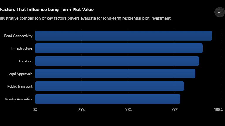
Connectivity Factors — Relative Buyer Importance (Illustrative)
| Factor | Relative Importance (out of 10) |
|---|---|
| Highway/Road Access | 9 |
| Travel Time to Workplace | 9 |
| Public Transport Availability | 7 |
| Proximity to Schools/Hospitals | 8 |
| Internal Road Quality | 7 |
| Future Infrastructure Plans | 8 |
Infrastructure Influence on Locality Growth (Illustrative)
Buyer Priorities When Selecting a Plot (Illustrative)
| Priority | Weightage (out of 10) |
|---|---|
| Connectivity | 9 |
| Price per Sq. Ft. | 7 |
| Approvals (NMRDA/RERA) | 8 |
| Amenities in Layout | 6 |
| Future Development Potential | 8 |
Travel Time vs Distance — Buyer Perception (Illustrative)
| Metric | Perceived Importance by Buyers (out of 10) |
|---|---|
| Raw Distance (km) | 4 |
| Actual Travel Time | 9 |
| Peak-Hour Reliability | 8 |
Property Value Drivers (Illustrative)
| Driver | Relative Weight (out of 10) |
|---|---|
| Connectivity & Accessibility | 9 |
| Infrastructure Development | 8 |
| Approvals & Clear Title | 8 |
| Local Amenities | 6 |
| Broader Market Conditions | 7 |
Note: The charts above are illustrative, based on general buyer behaviour patterns and infrastructure principles. They are not statistical guarantees or predictions of price movement.
Frequently Asked Questions
1. Why is connectivity more important than distance when buying a plot? Distance only tells you how far a plot is on a map, while connectivity tells you how easily you can actually reach it. A plot that is technically closer but accessed through narrow, congested roads can take longer to reach than one that is farther away but connected by a highway. Buyers who focus only on distance often overlook the daily reality of commuting, which affects both convenience and long-term demand. Evaluating connectivity gives a more accurate picture of how usable and desirable a plot will be in daily life, which is why experienced buyers and planners increasingly prioritise travel time over raw distance figures.
2. What is the difference between distance and travel time? Distance is a fixed measurement, usually in kilometres, between two points. Travel time is how long it actually takes to cover that distance, which depends on road width, traffic conditions, road quality, and time of day. Two plots at the same distance from a city can have very different travel times depending on their access routes. This is why simply checking “how many km” on a brochure is not enough. A more useful approach is to physically check travel time at different times of day before making a decision.
3. How does connectivity affect residential demand? When travel time to workplaces, schools, and markets decreases, more families and professionals consider a locality for daily living. This gradual increase in interest is what drives residential demand over time. Areas with poor connectivity tend to attract only price-sensitive buyers, while well-connected areas attract a broader mix of end-users and investors. Since demand is one of the key factors influencing how a locality develops, connectivity indirectly shapes the pace and pattern of residential growth in a region.
4. Does proximity to a highway guarantee property value growth? No single factor can guarantee value growth, and highway proximity is no exception. What highway access does is reduce travel time to major economic centres, which can make an area more attractive to buyers and support demand over time. However, actual property value depends on multiple factors, including infrastructure execution, local demand-supply balance, approvals, and broader market conditions. Buyers should treat highway access as one positive factor among several, not as a standalone guarantee of future returns.
5. What role do ring roads play in property value? Ring roads help redistribute traffic away from congested city centres, making peripheral localities easier to access without routing through the busiest parts of a city. This improved circulation can make previously overlooked areas more attractive for residential development. Localities near ring road junctions often see faster infrastructure follow-through, such as better internal roads and utility connections, which can support long-term liveability and buyer interest in that area.
6. How can I check the future infrastructure plans for an area before buying a plot? You can check with the relevant local development authority, such as NMRDA for Nagpur, for sanctioned or proposed road, metro, and infrastructure projects near your shortlisted plot. Government master plans and development notifications are also useful sources. Additionally, speaking with local residents, shopkeepers, or a trusted real estate consultant familiar with the area can provide practical, on-ground insights that aren’t always visible in official documents alone.
7. Why do buyers often make the mistake of choosing distance over connectivity? Distance is easy to state and compare — it’s a single number on a brochure or map. Connectivity, on the other hand, requires more effort to evaluate, including checking road conditions, travel time at different hours, and future infrastructure plans. Many buyers default to the simpler metric because it feels more concrete, even though it doesn’t reflect the real day-to-day experience of living in or visiting that location. Taking the extra time to evaluate connectivity leads to more informed decisions.
8. Are NMRDA and RERA approvals related to connectivity? Approvals themselves don’t guarantee connectivity, but approved layouts are generally more likely to receive planned civic infrastructure, including roads, drainage, and electricity, in a structured and timely manner. NMRDA approval confirms that a layout meets regional development authority standards, while RERA approval ensures regulatory compliance and transparency for buyers. Checking both approvals is an important step, alongside evaluating connectivity, before finalising any plot purchase.
9. How does travel time affect resale value of a plot? Plots in areas with shorter, more predictable travel times to workplaces and city centres tend to attract a wider pool of interested buyers when it’s time to resell. A larger buyer pool generally supports a smoother resale process. Conversely, plots in poorly connected areas may take longer to sell or may attract fewer serious buyers, since the daily inconvenience of poor connectivity is a genuine deterrent for most end-users, not just investors.
10. Should I avoid buying a plot just because it’s slightly farther from the city? Not necessarily. A plot that is farther but well-connected via a highway or ring road can be more accessible in practice than a closer plot with poor roads. The key is to evaluate actual travel time and infrastructure rather than dismissing a location purely based on its distance from a reference point. Many well-planned townships are located beyond immediate city limits precisely because that’s where space for planned infrastructure exists.
11. What questions should I ask before buying a plot near an upcoming highway or metro project? Ask whether the project is officially sanctioned or still under proposal, what the expected timeline is, and whether the development authority has published any formal notifications. It’s also worth asking how the project will specifically connect to the plot’s location, since “nearby” can sometimes mean several kilometres away. Getting this information from official sources, rather than relying solely on marketing claims, helps set realistic expectations.
12. Can Bhumesh Realtors help me evaluate connectivity before buying a plot? Yes. Our team assists buyers with site visits, layout approval verification, and general guidance on infrastructure and connectivity factors for our NMRDA and RERA approved projects across Nagpur, including areas like Wardha Road, Dongargaon, and Hingna-Isasani. While we can share what is publicly known about planned infrastructure, we encourage every buyer to independently verify details with the relevant government authorities before making a final decision.
Written by Ashavini Durugkar Peshane
Founder, Bhumesh Realtors | Real Estate Educator | Land Investment Researcher
Bhumesh Realtors
Trusted real estate company in Nagpur since 2018, offering NMRDA & RERA approved plots with up to 90% bank loan assistance. Over 3,000+ plots sold across prime Wardha Road locations.
Address: 4 th Floor, Lusin Tower, Wardha Road Nagpur, 440015
Phone: +0712 2222712 +919370159082
Website: https://bhumeshrealtors.com/
Email: digital.bhumesh@gmail.com contact@bhumeshrealtors.com
You tube link: https://www.youtube.com/@bhumeshrealtors5206
Instagram : https://www.instagram.com/bhumesh_realtors/
Twitter : https://x.com/BhumeshRealtors
Facebook : https://www.facebook.com/bhumeshrealtors/
Linked in : https://www.linkedin.com/company/bhumesh-realtors/



Comments are closed