






Buying a residential plot is one of the biggest financial decisions most families make. Yet, a surprising number of buyers sign a booking form after looking at a layout plan for barely five minutes.
A layout plan is not just a colourful map with boxes and lines. It is a technical document that tells you almost everything about a plotting project — where your plot sits, how wide the roads are, whether there is enough open space, and whether the project has been sanctioned by the right authority.
If you can read a layout plan correctly, you can avoid years of regret. If you cannot, you may end up with a plot next to a garbage collection point, facing a narrow internal lane, or worse — inside a layout that was never legally approved.
This guide breaks down every symbol, term, and section of a typical residential plot layout plan so that you can walk into any site visit with confidence, ask the right questions, and make an informed decision.
This article is meant purely for educational purposes. It does not constitute legal or financial advice. Always verify documents with a qualified advocate and a registered financial consultant before making any payment.
What Exactly Is a Residential Plot Layout Plan?
A residential plot layout plan is a scaled drawing that shows how a piece of land has been divided into individual plots, roads, open spaces, and common amenities. It is prepared by a licensed town planner or architect and, in most cases, has to be approved by a competent planning authority before plots can be legally sold.
Depending on the city, the approving authority could be a Municipal Corporation, an Improvement Trust, a Regional Development Authority such as NMRDA in Nagpur, or a Town and Country Planning department. Once sanctioned, the layout gets an approval number, which should be printed on the official layout copy.
Think of the layout plan as the “blueprint of a neighbourhood” — much like a floor plan is the blueprint of a house.
Table of Contents
Why Reading the Layout Plan Correctly Matters
Many buyers focus only on the price per square foot and the plot size. But the layout plan reveals details that directly affect your daily life and your property’s future value, such as:
- How close your plot is to the main entrance
- Whether you face a busy internal road or a quiet lane
- How far you are from garden zones versus utility zones
- Whether your plot has independent access or shares a common passage
- Whether the layout has been legally sanctioned at all
A plot that looks identical on paper to another can have a very different real-life experience once the township is developed. That’s why urban planners and experienced property consultants always recommend a proper layout reading session before booking.
Key Elements of a Residential Plot Layout Plan Explained
1. Plot Number
Every plot in a sanctioned layout carries a unique plot number. This number appears on the layout map as well as on your allotment letter and registry documents. Always cross-check that the plot number mentioned in your booking form matches the number shown on the physical layout map and, later, on the actual demarcated plot at the site.
Practical example: If your booking slip says “Plot No. 42” but the site supervisor points to a plot marked “42-A” on the ground, ask for clarification in writing before proceeding.
2. Plot Orientation and North Direction
Every layout plan carries a North direction arrow, usually in one corner of the map. Orientation tells you which direction your plot faces — north, south, east, or west — which matters for sunlight, ventilation, and, for many Indian families, Vastu considerations.
Tip: Stand at the actual plot location with a compass app and confirm that the direction matches what is printed on the layout. Paper orientation and ground orientation should always align.
3. Road Width
Road width is one of the most overlooked yet important factors. Wider roads mean better ventilation, easier vehicle movement, and generally higher resale value. Layout plans typically show two categories of roads:
- Main/Approach Road – the primary road connecting the layout to the highway or city road
- Internal Roads – smaller roads within the layout connecting individual plots
A plot facing a 40-feet main road is usually valued differently from a plot facing a 20-feet internal lane.
4. Internal Road Network
The internal road network shows how roads branch out from the main entrance to reach every plot. A well-planned internal network avoids dead ends, ensures every plot has road access, and allows emergency vehicles like ambulances or fire trucks to reach any point in the layout.
5. Entry and Exit Points
Look for the marked main gate, entry point, and any secondary exit. A layout with only one entry/exit can experience congestion during peak hours, especially in larger townships. Some premium layouts plan separate entry and exit lanes for smoother traffic flow.
6. Garden and Landscaped Areas
Garden zones are shown as green-shaded areas on the layout. These spaces add aesthetic value, provide a walking/recreation area for residents, and often become a selling point for family buyers. A plot located near a garden zone (without directly bordering utility lines) is generally seen as desirable.
7. Open Space / Amenity Space
Under most development control regulations, a certain percentage of the total layout area must be reserved as open space or recreational ground. This is not optional — it is a planning requirement. Layout plans mark this clearly, often labelled as “Recreational Open Space” or “Amenity Space.”
Why it matters: Open space reservation is one indicator that a layout has been planned according to sanctioned norms, rather than squeezed purely for maximum plot count.
8. Clubhouse
In gated townships, the clubhouse is usually shown as a distinct built structure on the layout, often near the entrance or central to the community. It typically houses recreational facilities. Its location affects both convenience and noise levels for nearby plots.
9. Temple or Community Worship Space
Many residential townships in India include a small temple or community worship area, marked separately on the layout. While this is a lifestyle and cultural feature rather than a legal requirement, its placement can influence footfall and activity near certain plots.
10. Utility Areas
Utility areas include electrical substations, water tanks, sewage treatment plants, and garbage collection points. These are essential for the township to function, but plots located directly adjacent to utility areas may experience noise, odour, or reduced privacy.
Expert advice: Always ask specifically where utility areas are marked on the layout and physically visit that zone before finalising a plot near it.
11. Drainage System
The layout plan (or an accompanying infrastructure plan) should show the underground or surface drainage network. Proper drainage prevents waterlogging during monsoon season — a common and serious issue in poorly planned layouts.
12. Water Line
Water supply lines, whether connected to municipal supply or a borewell-based system, should be indicated in the infrastructure layout. Confirm whether individual plots get direct water connections or whether water is distributed through a common network.
13. Electric Line
Electrical connectivity, including transformer locations and cable routing, is usually part of a separate services layout. Buyers should confirm whether individual electric meters are provided per plot and how far the nearest connection point is.
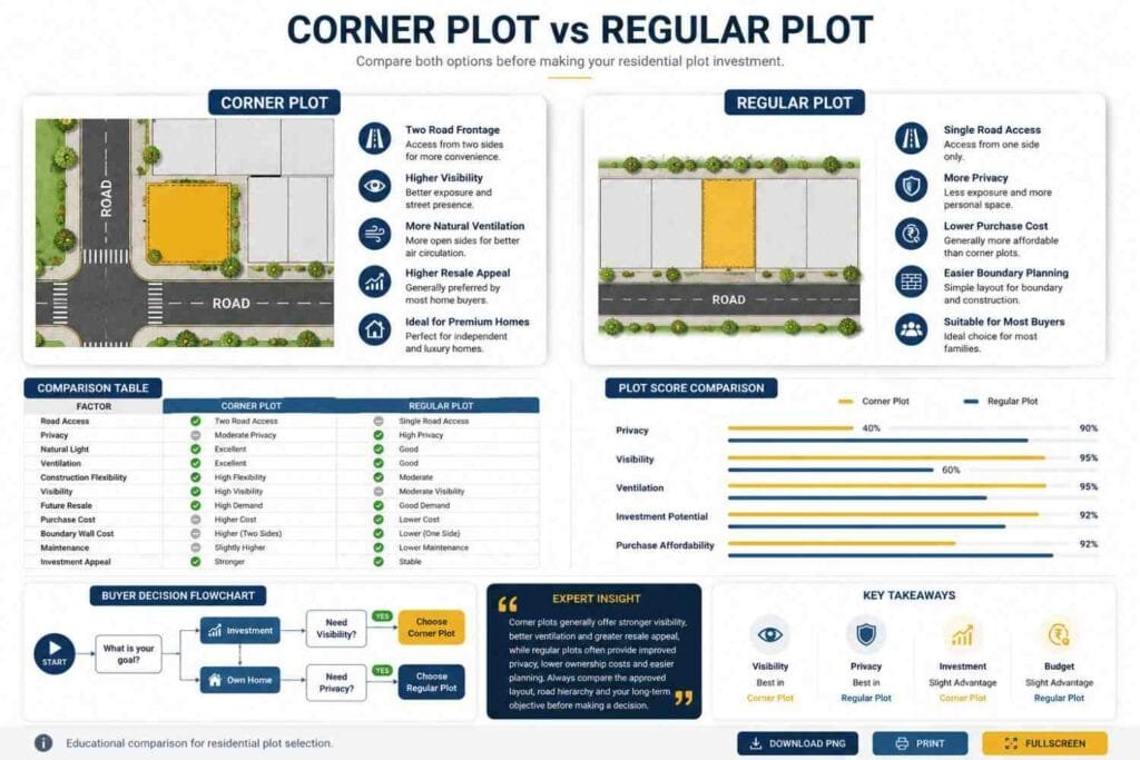
14. Corner Plot
A corner plot touches two roads instead of one. On the layout map, it is easy to identify because two edges of the plot border road lines rather than neighbouring plots. Corner plots often command a price premium due to additional access, light, and ventilation — but they can also mean less privacy and higher boundary wall costs.
15. Park-Facing Plot
A park-facing plot borders a garden or open green zone rather than another plot or a busy road. These are usually more sought after for the view and lower noise levels, and may carry a premium price.
16. Commercial Area / Commercial Zone
Some townships reserve a small section for shops or commercial use, clearly marked separately from residential plots. Buyers of nearby residential plots should check the distance from this zone, as very close proximity can mean more footfall and noise, while a moderate distance can add convenience.
17. Future Expansion Zone
Larger developments sometimes reserve adjoining land for future phases. This can be a positive sign (indicating a builder’s long-term commitment) or something to watch for extended construction activity nearby during your initial years of ownership.
18. Legal Approval and Layout Sanction
This is the single most important element of any layout plan. A sanctioned layout carries an approval number from the relevant authority (NMRDA, Municipal Corporation, Improvement Trust, or equivalent), along with the sanctioning authority’s stamp and signature. Always ask for a copy of the sanctioned layout plan — not just a marketing brochure — and verify the approval number independently with the concerned department.
Approved vs Unapproved Layout — Comparison Table
| Feature | Approved (Sanctioned) Layout | Unapproved Layout |
|---|---|---|
| Legal Status | Sanctioned by competent authority (NMRDA/Municipal Corporation/Improvement Trust) | No official sanction; often informally divided |
| Registry | Smooth registration process | Registration may be denied or delayed |
| Bank Loan | Eligible for home/plot loans in most cases | Banks generally refuse to finance |
| Infrastructure | Roads, drainage, open space as per norms | Often missing planned infrastructure |
| Resale Value | Higher and more stable | Lower, with legal uncertainty affecting resale |
| Future Risk | Low, if all documents are verified | High risk of demolition or legal disputes |
Corner Plot vs Regular Plot
| Feature | Corner Plot | Regular Plot |
|---|---|---|
| Road Access | Faces two roads | Faces one road |
| Ventilation & Light | Generally better | Standard |
| Privacy | Lower, due to two open sides | Higher |
| Boundary Wall Cost | Higher (more perimeter facing roads) | Lower |
| Price | Usually at a premium | Standard pricing |
Internal Road Width Comparison
| Road Type | Typical Width Range | Common Use |
|---|---|---|
| Main Approach Road | 30–60 feet | Primary entry, heavy vehicle movement |
| Secondary Internal Road | 20–30 feet | Connects plot clusters |
| Tertiary/Lane Road | 12–20 feet | Access to individual plots |
Actual widths vary by project and sanctioning authority norms; always confirm specific figures from the sanctioned layout copy.
Residential vs Commercial Zone
| Aspect | Residential Zone | Commercial Zone |
|---|---|---|
| Usage Permitted | Homes, residential buildings | Shops, offices, commercial establishments |
| Noise & Footfall | Generally lower | Higher, especially during business hours |
| Ideal For | Families seeking a quiet environment | Investors seeking rental/business income |
| Zoning Approval | As per residential zoning norms | As per commercial zoning norms |
Park-Facing Plot vs Internal Plot
| Feature | Park-Facing Plot | Internal Plot |
|---|---|---|
| View | Open green view | Faces neighbouring plots |
| Noise Level | Lower | Depends on internal road traffic |
| Price | Often at a premium | Standard pricing |
| Ventilation | Generally better | Standard |
Layout Features Checklist Table
| Feature | Present (Yes/No) | Notes |
|---|---|---|
| Sanctioned Layout Number | ||
| Internal Roads Marked | ||
| Open Space Reserved | ||
| Drainage System Shown | ||
| Water Line Marked | ||
| Electric Line Marked | ||
| Garden/Green Zone | ||
| Clubhouse (if applicable) | ||
| Corner/Park-facing Options | ||
| Commercial Zone Marked |
Plot Evaluation Matrix
| Evaluation Factor | Weight (Approx.) | Your Observation |
|---|---|---|
| Legal Approval | High | |
| Road Width & Access | High | |
| Open Space Proximity | Medium | |
| Distance from Utility Zone | Medium | |
| Orientation | Medium | |
| Price per Sq. Ft. | High |
Road Hierarchy Comparison
| Road Level | Purpose | Typical Location on Layout |
|---|---|---|
| Primary Road | Connects layout to main highway/city road | Layout boundary |
| Secondary Road | Distributes traffic within the layout | Central spine |
| Tertiary Lane | Direct plot access | Between plot clusters |
Step-by-Step: How to Read Any Layout Plan (Practical Walkthrough)
- Locate the North direction arrow first. This orients every other element on the map.
- Identify the main entry gate and trace the primary approach road from there.
- Check internal road widths as marked in the legend or accompanying notes.
- Locate garden, open space, and clubhouse zones, and note their distance from your shortlisted plot.
- Find utility areas such as water tanks, transformers, and drainage lines, and check their distance from your plot.
- Locate your specific plot number and confirm it matches your booking documents.
- Verify the layout sanction number with the relevant planning authority before making any payment.
A Simple Layout Reading Diagram
                 NORTH ↑

   Main Road ───────────────────────────
        |                              |
   [ Entry Gate ]                [ Exit ]
        |
   ---- Internal Road A ----
   | Plot 1 | Plot 2 | Plot 3 |
   ---- Internal Road B ----
   | Plot 4 | Garden/Open Space | Plot 5 |
   ---- Internal Road C ----
   | Clubhouse |  Plot 6  | Utility Zone |
This is a simplified illustrative diagram. Always refer to the actual sanctioned layout copy of your project for accurate details.
Common Mistakes Buyers Make While Reading a Layout Plan
- Trusting a brochure instead of the sanctioned layout copy. Marketing brochures are simplified and may not show every legal detail.
- Ignoring the North direction, then being surprised by unexpected sun exposure or Vastu mismatch after construction.
- Not checking road width, resulting in a narrow, congested access lane.
- Overlooking nearby utility zones, then facing noise or odour issues after possession.
- Assuming a plot number on the brochure matches the one on the ground without physical verification.
- Skipping verification of the layout sanction number with the concerned authority.
- Not asking about future expansion plans, which could mean years of nearby construction activity.
Expert Tips Before You Book a Plot
- Always request a printed, sanctioned layout copy — not just a digital marketing image.
- Visit the site physically and match the ground reality with the layout map.
- Ask the developer directly for the layout approval number and verify it independently.
- Compare at least two to three plots within the same layout before finalising one.
- Keep a written record of all verbal commitments made regarding amenities or timelines.
- Consult an independent advocate to review title documents and approval papers before payment.
What Smart Buyers Check Before Booking
Checklist importance while reading a residential layout plan.
Buyer’s Layout Verification Checklist
☐ North Direction Confirmed
☐ Plot Number Matches Documents
☐ Internal Roads Reviewed
☐ Road Width Verified
☐ Garden/Green Zone Location Checked
☐ Temple/Community Space Noted (if applicable)
☐ Drainage System Confirmed
☐ Water Line Availability Checked
☐ Electric Line Availability Checked
☐ Clubhouse Location Reviewed (if applicable)
☐ Open Space Reservation Verified
☐ Commercial Zone Distance Checked
☐ Parking Provision Reviewed
☐ Entry/Exit Points Identified
☐ Security Arrangements Discussed
☐ RERA Registration Verified
☐ Layout Sanction / NA Order Verified
☐ Sanctioned Building/Layout Plan Copy Obtained
Timeline: A Typical Plot-Buying Journey
- Receive Brochure
- Visit Site
- Study Layout Plan
- Verify Approvals
- Compare Plots
- Finalise Plot
- Registration
Each stage matters. Skipping directly from “Receive Brochure” to “Finalise Plot” without studying the layout and verifying approvals is where most regretful purchases begin.
Where Bhumesh Realtors Fits In
At Bhumesh Realtors, we have guided plot buyers across Nagpur since 2018 through exactly this process — reading layout plans, understanding NMRDA and RERA approvals, and comparing plot options across our residential projects along Wardha Road and surrounding growth corridors. If you would like a layout plan explained in person before you book, our site visit team is available to walk you through it.
That said, the principles in this guide apply to any layout plan, from any developer, anywhere in India — not just our own projects.
Key Takeaways
- A residential plot layout plan is a technical, legal document — read it carefully, not casually.
- Always verify the North direction, road width, and your exact plot number against official documents.
- Open space, drainage, water, and electric lines are not optional extras — they indicate whether a layout is genuinely planned.
- Corner plots and park-facing plots usually carry a price premium, but come with trade-offs like privacy or boundary costs.
- The single most important check is the layout’s legal sanction and RERA registration — always verify independently before paying.
- This guide is educational; consult a qualified advocate and financial advisor for legal and financial decisions.
Conclusion
A layout plan tells a story — about how a piece of land was designed to become a neighbourhood. Learning to read that story properly means you are no longer a passive buyer relying purely on a salesperson’s pitch. You become someone who can independently judge whether a plot fits your family’s needs and your investment goals.
Take your time before booking. Ask for the sanctioned layout copy, verify the approval number, walk the site with the map in hand, and compare more than one option. A few extra hours spent reading a layout plan carefully can save years of complications later.
Frequently Asked Questions
1. What is a residential plot layout plan? A residential plot layout plan is a scaled, technical drawing prepared by a licensed town planner or architect that shows how a piece of land is divided into individual plots, roads, open spaces, and common amenities. It also indicates orientation, road widths, and utility locations. Once approved by the relevant planning authority, it becomes the official reference document for that project. Buyers should always request this sanctioned copy rather than relying solely on a marketing brochure, since the brochure may simplify or omit certain technical details that matter for long-term ownership and resale value.
2. How do I find the North direction on a layout plan? Most layout plans include a small arrow, usually labelled “N,” in one corner of the drawing. This arrow indicates true North and is used as the reference point for describing plot orientation. Once you identify it, you can determine whether a plot faces north, south, east, or west. It’s a good practice to also confirm this using a compass app while standing on the actual site, since ground orientation should always match what is shown on the official layout document.
3. Why does road width matter when choosing a plot? Road width affects daily convenience, vehicle access, ventilation, and often the long-term resale value of a plot. Plots facing wider main roads generally experience better traffic flow and higher visibility, while those on narrower internal lanes may face congestion, especially in densely developed layouts. Road width also has implications for emergency vehicle access. Reviewing the layout’s road hierarchy — main road, secondary road, and internal lanes — helps you understand exactly what kind of access your chosen plot will have once the township is fully developed.
4. What is the difference between a corner plot and a regular plot? A corner plot touches two roads instead of one, offering additional light, ventilation, and access. Regular plots typically border neighbouring plots on two or more sides and face only a single road. Corner plots are often priced at a premium due to their added access and visibility, but they usually require higher boundary wall investment and offer somewhat less privacy compared to a regular plot tucked within a row. Your choice should depend on whether you prioritise access and visibility or privacy and lower upfront costs.
5. What does “open space” mean in a layout plan? Open space refers to land within a layout that is reserved for recreational or amenity use rather than sold as plots. In most jurisdictions, developers are required to reserve a certain percentage of the total layout area as open space under applicable planning regulations. This space often becomes a garden, playground, or community area. Its presence and proper marking on a sanctioned layout is a good indicator that the project follows planning norms rather than maximising plot count at the cost of livability.
6. How can I verify if a layout is legally approved? Ask the developer for the sanctioned layout copy, which should display an approval number, the sanctioning authority’s name (such as NMRDA, a Municipal Corporation, or an Improvement Trust), and an official stamp or signature. You can then independently verify this approval number with the concerned planning authority’s office or official website. Additionally, check whether the project is registered under RERA, as this registration number can usually be verified on the respective state’s RERA portal. Never rely solely on verbal assurances from a sales representative.
7. What is the difference between NMRDA approval and RERA registration? NMRDA (or the equivalent local planning authority) approval confirms that the layout itself — the division of land into plots, roads, and open spaces — meets planning and zoning regulations. RERA registration, on the other hand, is a separate regulatory requirement under the Real Estate (Regulation and Development) Act, aimed at protecting buyers through project disclosures, timelines, and accountability. A genuinely compliant project should ideally have both: a sanctioned layout from the planning authority and, where applicable, RERA registration.
8. Are utility areas like transformers and water tanks marked on the layout plan? Yes, in a properly prepared layout, utility areas such as electrical substations, water tanks, sewage treatment facilities, and garbage collection points are marked separately from residential plots. These are essential for the township’s functioning, but plots located immediately adjacent to them may experience additional noise or reduced privacy. It’s advisable to specifically ask where these zones are located on the map and to physically visit that area during your site visit before finalising a plot near it.
9. What is a park-facing plot, and is it worth paying extra for? A park-facing plot borders a garden or reserved green zone instead of another plot or a busy road. These plots typically offer a more open view, better ventilation, and lower noise levels, which is why they are often priced at a premium. Whether it’s “worth” the extra cost depends on your personal priorities — families who value greenery and a quieter environment often find the premium justified, while purely investment-focused buyers may prioritise other factors like road width or proximity to commercial zones instead.
10. Can the layout plan change after I book a plot? In a properly sanctioned layout, the approved plan should not be altered without fresh approval from the sanctioning authority, since any deviation could affect legal compliance. However, buyers should still request updated layout copies periodically, especially in large, multi-phase townships, and confirm in writing that their specific plot’s dimensions, number, and location remain unchanged. If any deviation is proposed, it should be disclosed formally and, where required, re-approved by the relevant authority.
11. What documents should I ask for along with the layout plan? Along with the sanctioned layout copy, buyers should request the 7/12 extract or equivalent land record, the title/ownership documents, the layout approval letter from the planning authority, the RERA registration certificate (if applicable), and any NA (Non-Agricultural) order relevant to the land. These documents collectively help confirm both the legal status of the land and the specific plot within the sanctioned layout. It’s advisable to have an independent advocate review all documents before making any payment.
12. Is it necessary to physically visit the site, or is studying the layout plan enough? Studying the layout plan is essential, but it should never replace a physical site visit. Ground conditions — actual road construction status, distance to utility zones, surrounding developments, and even network connectivity — can only be confirmed on-site. A physical visit also allows you to verify that your plot’s boundaries, orientation, and access match exactly what is shown on the layout document, reducing the risk of any mismatch between paper plans and ground reality.
About Bhumesh Realtors
Trusted real estate company in Nagpur since 2018, offering NMRDA & RERA approved residential and commercial plots with up to 90% bank loan assistance. Over 3,000+ plots sold across prime Wardha Road locations.
Address: 4th Floor, Lusin Tower, Wardha Road, Nagpur – 440015
Phone: +91 712 2222712 | +91 9370159082
Website: https://bhumeshrealtors.com
Email: digital.bhumesh@gmail.com | contact@bhumeshrealtors.com
Follow Us
- YouTube: https://www.youtube.com/@bhumeshrealtors5206
- Instagram: https://www.instagram.com/bhumesh_realtors/
- Twitter/X: https://x.com/BhumeshRealtors
- Facebook: https://www.facebook.com/bhumeshrealtors/
- LinkedIn: https://www.linkedin.com/company/bhumesh-realtors/



Comments are closed